Falcon Overheight Vehicle Detection & Warning System
ABOUT FALCON
Falcon is a warning system used to alert over-height vehicles of an upcoming restrictive vertical clearance. This single highresolution sensor can scan multiple lanes with higher accuracy than traditional sensors.
SENSORS
A LiDAR sensor and camera can be mounted on existing DOT maintained poles to capture vehicles across multiple lanes as they travel at highway speeds.
SOFTWARE
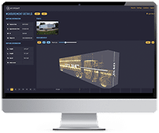
A web-based dashboard displays transactions in real-time. The displayed data includes the vehicle’s height and length, images of the vehicle, 3D dimensioning, a time stamp, axle count, axle position, and vehicle classification.
FALCON’S SOLUTION SYSTEM
The Falcon solution replaces less accurate solutions using a three-line scan to warn oversized vehicles of a potential collision with an upcoming overhead structure. Falcon consists of a 3D LiDAR sensor and camera to accurately measure vehicles as they travel at highway speeds. A dynamic message board is used to immediately signal overheight vehicles to exit before the upcoming bridge.
SYSTEM SPECIFICATIONS
Max Detection Range
200m at 30% reflectivity
Angular Resolution (H)2
0.35°
Frame Rate
380 Hz; 1140 lines/sec
Range Accuracy
± 3 cm
Laser Wavelength
905 nm
Laser Safety
Class 1 (eye safe)
Operating Temperature
-40°C to +65°C
Environmental Protection
IP67
Points per Second
315K (single return)
ACCURATE, REAL-TIME TRAFFIC COUNT
Transportation agencies need accurate data to forecast budgeting for highway maintenance. Falcon replaces traditional traffic count systems and provides accurate, up-to-date traffic counts with additional data available that older traffic systems cannot provide. The traffic can be filtered by date, height, length and speed. Once installed, Falcon will provide constant traffic count data.
IMMEDIATELY AVAILABLE DATA
Multiple data sets are instantly available to agency users. There is no need to lay temporary count cables or install traffic count devices in the pavement roadbed. Falcon can easily be remounted along different roadways wherever existing DOT-maintained poles exist.
INTUITIVE SOFTWARE AND DASHBOARD
Falcon clients access live or archived data using an ESRI ArcGIS Dashboard. Summarized data can be viewed using custom filters. Each individual vehicle data point can be viewed by clicking on the Falcon link in the Traffic tab. An image of each vehicle is captured along with 3D LiDAR scan which provides accurate dimension measurements.
Single vehicle selected for view on ESRI Dashboard